Sunday, June 30, 2013

College Writing Tips: Read the Question

My teaching career began in the fall of 1997 when a faculty member experienced a heartache about a week before the semester began. During the intervening years between then and today, my peers, colleagues, and even those in business & industry, have noticed a tremendous decline in people's ability to write.

Recently, I spent many hours grading writing assignments. These writing assignments ran the gamut from "short answers" to "essay" to 3 page response-type papers. My response papers are based on listening to two podcasts. One podcast is an economics podcast discussing the geographic traits of snack food. The other podcast is a mesmerizing account of a couple of Americans travelling throughout a South Asian country.

The more I read, the more patterns in writing emerged. Not just patterns in thought; writing involves considerable thinking. I tend to reason writing reveals thinking, how a person thinks, how a person organizes thoughts and information. Writing reveals a considerable amount of information about a person, and I can understand how writing makes people nervous. I'm nervous merely writing this post, but I'm dealing with it.

Writing in higher education doesn't have to involve the level of stress people attach to writing assignments. Understanding some simple concepts, requirements, goals, and using the education which was provided from ages 6-18 (maybe 16 in Kentucky) can alleviate anxiety surrounding writing.
I am going to walk through some of the common errors I find in writing. Not only will I identify errors but I'll explain how to adjust thinking processes to help direct attention to formulating better academic responses to writing assignments.

Writing Tip One:  "Read the Question"

One of the easiest ways to achieve better writing scores is simply to read the question. Qualitatively, I estimate about 1 in 4 students do not actually consider question details. The ratio may be higher, I'll admit. Take an inventory of the requirements of the question. Look for key words, like "explain" or "discuss" or "describe." Such words indicate a simple sentence or two will not pass the muster. Students tend to provide a list of objects, thoughts, or details and consider the list they have provided a "discussion." Whether the items are provided in bullet form, or merely separated by commas, lists are not "discussions."
"Describe the sources of information meteorologists use for collecting information about the upper atmosphere."
A poor answerWeatherpeople have lots of ways of getting info about the air. Planes, balloons, and satellites give them the info they need to make weather maps.

A better answerMeteorologists have a few ways of obtaining information about the upper atmosphere. Aircraft can collect weather information, weather balloons are sent into the atmosphere to collect data, and satellites send images of weather systems back to Earth.

A good answerMeteorologists have several means of obtaining information about the upper atmosphere. The upper atmosphere is the portion of the Earth's atmosphere which includes in the troposphere, from the surface to about 60,000ft. Many commercial aircraft have on-board equipment which transmits data to ground stations. Radiosondes and rawinsondes (weather balloons) collect weather data near major airports. NOAA and other countries place weather satellites in orbit which collect images of the Earth which track storms, measure water vapor, and measure atmospheric temperatures.

Students frequently make the mistake believing their audience is their professor. Yes, the professor may grade the short answer, essay, or paper but thinking the professor was the intended audience can mentally trap a student. If a student believes the instructor is the intended audience important, relevant information may be omitted. I have had students tell me or email me, "Why do I need to be so detailed? Don't you know the answer? I thought you knew this?!"

Whether I know, or do not know, the "answer" is not the real issue. The real issue relates to the informational content of the response. Students should not write as if the instructor is the intended audience. The audience should NOT be thought of as the professor but rather some ignorant individual who needs to learn about the topic. When the student can think of themselves as the educator, then the real learning begins. I tell my students "write as if you are educating someone, not writing to me as if I know something."

Simply put, the student's job is to communicate the breadth and depth of their knowledge to the professor.

Provide enough details, facts, evidence, and examples for us to evaluate.

Next: "Use The Lingo"

Monday, June 17, 2013

Drones To The Rescue! Drones Use in Disaster and Emergency Services

Drones have many applications, are considered by many fields and disciplines to be incredibly useful tools. My concern lies with our governments use and potential misuse of drones in the targeted killing of military targets. Many innocent people have been killed, women and children, alongside the intended target. As a result, drones have suffered serious damage to their reputation before any non-lethal, non-military drones implemented for any number of benign tasks for which they are eminently capable and perhaps better suited than a human-occupied aircraft.

In my first post, I provided an overview of many issues associated with drones. In closing my first post I hinted I would author future posts, offering some current or potential uses. Some of the applications I identify are currently in use, with potential for growth; other applications are more future-looking, not in place today, but perhaps in the not-so-distant future.

In my second post, I discussed another field where drone use is opening doors to new exploration techniques. Archaeology is finding many uses for a remotely-piloted aircraft, or unmanned aerial systems (UAS). Kites are being equipped with digital cameras. Balloon kits allow researches to hoist digital cameras aloft. More detailed archaeological surveys mandate stability unattainable from kites and balloons. The survey of archaeological sites must be systematic. Flight lines need to be planned in advance of a survey to ensure capture of the area of interest (AOI). Scale of acquired imagery needs to be established. Scale and resolution of acquired imagery must be considered before flying a drone. When the details of the mission have been thoroughly accounted, then imagery is acquired. With regards to UAS, several missions might be flown. The first mission might result in imagery, visually inspected, to help plan the geographic scope of future flights. Sometimes, interesting landforms which imply a cultural imprint can only be seen from above, impacting the scale and scope of later drone missions. In Europe, especially in the U.K., France, and Eastern Europe, drone use has improved the knowledge of culture imprints on the landscape, aided in the inventory of archaeological sites, aided in the detection, analysis, and interpretation of archaeological sites.

The third installment on civilian drone use introduces some concepts related to the electromagnetic spectrum. We have to remember our eyes are sensitive to only a small part of the total electromagnetic (EM) spectrum. We must also bear in mind the objects around us reflect EM energy in a variety of ways. Some objects emit EM energy in different wavelengths. My third installment introduces some elementary notions to help further the discussion and direct us to drone uses in agriculture.

In my fourth article on drone use I diverge from civilian uses, introducing public use drones. I also am aggregating many different fields into Disaster and Emergency Management / Services (DEM/DES). The scope of DES involves many different actors, NOAA, FEMA, state-level DES offices, and local search-and-rescue teams.

638-Artificial_Hummingbird.sff_.embedded.prod_affiliate.156
From helping with local tragedies to providing services for large-scale, region-wide disasters drones have a myriad of potential uses. Drones can come in a variety of sizes. Some drone prototypes are as small as hummingbirds. Many drones which I have in mind for crossover civilian/private and public use are typically less then 25lbs (12kg) and can easily fit inside a hardsided suitcase. Still other drones are larger, requiring some form of take-off and landing "strip" such as a sidewalk, street or roadway, or small airfield like those located outside most small towns. Many drones require zero landing strips. With 4 to as many as 8 electric or gas-powered engines, these drones are vertical take-off and landing (VTOL) capable.

Beale tests Global HawkMost drones available to the general public today cannot stay airborne for longer than perhaps 20 minutes. Powered by nickle-metal hydride (NiMH), Lithium ion (Li-Ion), or nickle-cadmium (NiCd) batteries flights will last the length of a single charge. Depending on the size of the vehicle, number and type of batteries, and payload drone flight time is usually less than 15 minutes. However, we know from press releases and news articles, some drones are huge and have flight times measured in days, not minutes, like the Northrop Grumman RQ-4A Global Hawk. Of course, these are not commercial drones; these are military grade drones.

The miniaturization prevalent throughout the cellular telecommunications industry paralleled by same or similar technology in tablets and e-readers are also becoming part of the drone industry. Computer and IC chips, GPS circuits, camera and video optics, WIFI and Bluetooth, open source operating systems, gyroscopes, barometers, audio chips, and USB connectivity integrate into current drone systems.
The era in which we live is experiencing an unprecedented volume of mingling technologies. Miniaturization coupled with mass-production parallel with new light-weight materials and ubiquitous access to technology and few barriers to entry for hobbyists or entrepreneurs has presented an environment rich with potential.

Within our lifetimes, we may not even drive in the traditional sense. Our very own cars will become drones, piloted using a symphony of technologies, open source programming, GPS, radar, and Bluetooth. We will see this first with very new, very expensive cars. The new 2014 Mercedes-Benz E-class will come equipped with a complex array of sensors, optics, and sophisticated image processing software. The sensor array and on-board computers will process input data and provide real-time feedback to the driver regarding lane traffic and obstacles ahead. The computers will apply brakes should the driver not react fast enough.

Eventually, all cars will be equipped as a standard package such sensor array. Additionally, cars will "talk" with each other via a Bluetooth-like local network. Vehicles will transmit data among themselves, direction of travel, velocity, mass, number of passengers, etc., in order to maintain constant and even traffic flow. Your vehicle will emit energy of some form to measure distances to nearby objects, to judge distance, speed, momentum, time to stop, and so forth. We already see this technology being introduced in small increments, like the backup sensors available in the Buick Enclave. Aftermarket backup sensors and cameras are available for retrofitting older cars and trucks.

What does any of this have to do with drones?

I wanted to discuss size and flight times to introduce the notion of the variety of platforms available to the general public and, potentially, public agencies. I also wanted to mention new technologies we are familiar with, technologies we find in our Kindle Fire, Samsung Galaxy iPhones, or Android tablets.
These two technologies are merging. Arduino software is open-source software, based on Java, and controls the input/output boards on many drones. Other boards have the capability of being controlled with the flavors of Linux or Android. These boards interface with a multitude of other technologies, like Bluetooth, WIFI, cameras and optics, audio and microphones, plus provide navigation via GPS technology. Moderately priced drones will transmit live HD video back to the remote pilot and capture JPEG images. Some of these drones can be piloted with a Kindle Fire or iPad simply by changing the orientation of the tablet.

The wide array of current off-the-shelf technology, low-cost, and few barriers to entry presents a fantastic opportunity for the development of drones designed to serve and protect the general public.
Drones equipped with thermal sensors have a number of important and life-saving uses. Imagine a person or people become lost in the wilderness, say Canyonlands National Park.   Launching a "flock" of a suitably-equipped drones might find lost hikers far sooner than sending out people on foot or 4WD vehicles, and reduces the risk of putting human pilots in the air. Furthermore, due to miniaturization associated with telecommunications, drones could also be equipped with WIFI or even cellular technologies which could ping a person's cell phone, thereby giving away their location. As the drone would also be equipped with GPS, rescuers would know precisely the location of the lost hiker.

Wildfires are a problem within many state and national forests. The same drones used for hunting lost hikers could also be flown for monitoring potential fuel sources, "hotspots," campers with illegal campfires, or assessing fire damage.

Earthquakes present a serious problem to utilities and communication lines. In fact, as I write this, a 6.6Mg earthquake has just struck Buli, Taiwan. We don't have to go too far back in time to recall the Sendei, Japan, earthquake. The Sendei earthquake presented a number of concerns. Transportation links to the region were broken. Communication and power were lost. Radioactive contamination resulted from damage to a nearby nuclear power facility. How could drones have facilitated aid to the public?
Granted, I am using Sendei as an example, but keep this in mind - the location does not matter. What fundamentally matters is the recognition of how differing technologies can be married together to address a problem. The country or nationality is not the issue.

Drones can be equipped with cellular technology and act as mobile cellular links. While the number of connections may be limited, rescuers would be able to penetrate the affected region and make phone calls.

Drones can be equipped as WIFI "hotspots." A flock of drones flying in a formation above an affected region could provide emergency Internet connectivity for both rescuers and those needing assistance. Both the WIFI and cellular technology could also be leveraged to locate trapped or injured people.
Human being emits thermal energy. Drones equipped with thermal sensors could also locate hurt or trapped individuals, or locate fires or heat sources not visible at ground level. Similarly equipped drones might also be equipped to "sniff" the air for noxious or flammable gases.

In the case of the Sendei earthquake and the damage to the nuclear power facility, a drone could have been flown into the affected area in lieu of putting people at risk. Drones equipped with radiation detectors could map out the extent of radiation.

With embedded GPS, all drone data has the potential of being mashed into mapping applications. A clever programmer/cartographer could generate on-the-fly maps of radiation contamination. But, we need not limit ourselves to radiation. Drones would be ideal for determining the plume from airborne pollutants released into the atmosphere.

Hurricanes represent another threat to public safety. While information is increasing in density each hurricane season, meteorologists and climatologists still lack data (and funding) for research. Huge gaps in our knowledge exist even with several weather satellites in geosynchronous orbit around Earth. Weather satellites provide us with important small-scale (large area) data, such as temperature, general details of atmospheric composition, cloud cover, cloud type, and sea surface temperatures.

Meteorologists need real-time, continual, data collection covering a variety of atmospheric variables. Changes in air pressure not only at the surface but aloft are critical to understanding the movement of upper level winds. Temperature and humidity aloft are also critical factors in determining cloud cover, cloud type, deposition, ice formation, and other elements important in storm formation.

Currently, a number of technologies have been implemented to augment the collection of weather data. Some commercial aircraft contain weather instruments which transmit data back to ground collection stations. Many Weather Watchers maintain private Stephenson Shelters which collect and send weather data to the National Weather Service (NWS). The station data then appear on websites like the Weather Underground.

WeatherBalloon.releaseAt about 92 stations around the United States weather balloons are sent aloft. These weather balloons carry a sensor package to about 100,000ft (20miles), collecting data during the ascent. Weather balloons are launched twice a day, at 6am and then again at 6pm. And, the payload is generally lost, but some people who find the payload do send the payload back to the NWS.

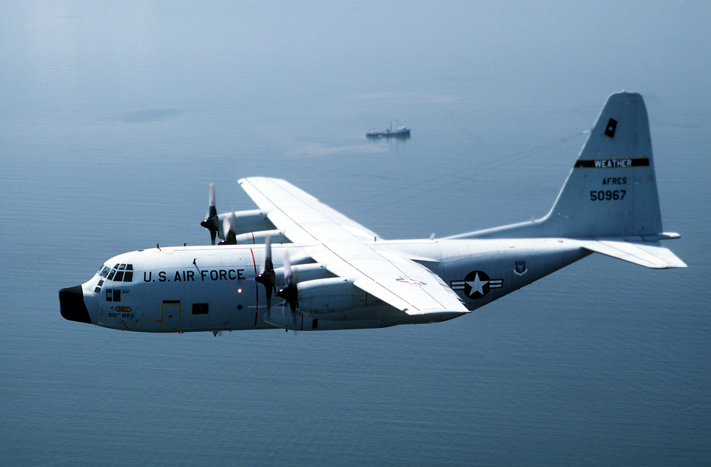
During hurricane season NOAA flies human-occupied aircraft into the heart of these powerful storm systems. While this sounds death-defying, read this account of a "boring" flight through a hurricane. The U.S. Air Force flies Lockheed WC-130 "Hurricane Hunters" on 10-hour long missions to collect data on a particular hurricane.

DF-ST-89-02039weather-droneNot to put any pilot out of work; they could be re-trained to fly a "hurricane hunting" drone. Drones similar to the Global Hawk could be modified to collect atmospheric data without placing human lives at risk. And, they could be flown more frequently with potentially a greater range. I'm imagining a greater range in order to study hurricane formation over western Africa, the "nursery" of our western hemisphere tropical storms and hurricanes.

I hope I've provided some food for thought. I follow the philosophy "tools are tools, its how people use them which provide context." A hammer can build a home for Habitat for Humanity, and, as fans of "Law and Order" or "Bones" can testify, a hammer can be used to bash in someone's skull. No doubt, drones have uses that could trample a person's right to Life, Liberty, and the Pursuit of Happiness, and privacy. Our government does not seem at all interested in protecting the private domain, which is both dangerous and disheartening. A drone with WIFI potential could easily snoop on internet traffic, or provide a platform for remote hacking of networks with absolute government complicity. And we have seen with the use of National Security Letters to circumvent warrants for collecting intelligence on U.S. citizens. No doubt, then, the potential for further comprise of a person's rights.

My next article may address some of those concerns. The current conversation going on across the United States varies from allowing only law enforcement access to drones, to allowing only private drone use, to the complete denial of drones to all. To me, all of this is simply unsophisticated, ignorance- and fear-based, which should come as no surprise since our government has continually leveraged perceived "fear" to assume more and more nuanced control over our daily lives since 9/11.

However, there are legitimate uses of drones within Public Safety and Law Enforcement. While many people would not agree, I will offer some perspectives and examples whereby drones would be preferable to putting a person at risk.

Finally, I'd like to thank some readers, for no other reason 56 of you selected to follow my blog, and I like to mention a few of you in each post. So, to Joe SeeberRachel BokKurt Rees, and last but not least, Jo, thanks for your attention.

PAX

Related articles

A Bird's Eye View of Farm Management: Drones in Agriculture

Drones have many applications, are considered by many fields and disciplines to be incredibly useful tools. In my first post, I provided an overview of many issues associated with drones. In closing my first post I hinted I would author future posts, offering some current or potential uses. Some of the applications I identify are currently uses, with potential for growth; other applications are more future-looking, not in place today, but perhaps in the not-so-distant future.

In my second post, I discussed another field where drone use is opening doors to new exploration techniques. Archaeology is finding many uses for a remotely-piloted aircraft, or unmanned aerial systems (UAS). Kites are being equipped with digital cameras. Balloon kits allow researches to hoist digital cameras aloft. More detailed archaeological surveys mandate stability unattainable from kites and balloons. The survey of archaeological sites must be systematic. Flight lines need to be planned in advance of a survey to ensure the capture of the area of interest (AOI). Scale of acquired imagery needs to be established. Scale and resolution of acquired imagery must be considered before flying a drone. When the details of the mission have been thoroughly accounted, then imagery is acquired. With regards to UAS, several missions might be flown. The first mission might result in imagery, visually inspected, to help plan the geographic scope of future flights. Sometimes, interesting landforms which imply a cultural imprint can only be seen from above, which might impact the scale and scope of later drone missions. In Europe, especially in the U.K., France, and Eastern Europe, drone use has improved the knowledge of culture imprints on the landscape, aided in the inventory of archaeological sites, aided in the detection, analysis, and interpretation of archaeological sites.

Wheat_P1210892I ask students in my all of my courses what color they see the most when they are outside in the late spring or early summer. Sometimes, they need some prompting; "What is the color of the vegetation you see when you go outside?" Usually, the answer is "green," which is sort of wrong. I'll explain why.

From high school physics, we learned about the Electromagnetic spectrum (EM). The EM spectrum is the range of energies emanating from the Sun and other objects. Our eyes, great as they are, are sensitive to a mere fragment of the entire spectrum of possible energies. The rods and cones in our eyes are stimulated by energies associated with colors ranging from violet to red. A simply mnemonic to remember the colors is ROY G BIV (red, orange, yellow, green, blue, indigo, violet). The arrangement is from longest wavelength to shortest wavelength.

spectral-reflectanceOur eyes are not sensitive to other energies, like radio waves, cosmic waves, x-rays, microwaves, or even energies just beyond the normal range, infra-red, or ultra-violet. Our natural environment, however, is very adept at reflecting energies beyond the range of our eyes to see.
At left, is a graph illustrating the reflectance of energy from the leaves of healthy vegetation, stressed vegetation, and severely stressed vegetation. "Stressed" means the vegetation has been affected by something, lack of water, lack of nutrients, presence of insects, or some form of blight.

Note the range of reflectance energies along the y-axis, and the range of reflectance wavelengths along the x-axis. Along the x-axis, we see the "visible" range, the range our eyes react to, the "near infra-red" range which we cannot see, and the short wave infra-red, which corresponds to thermal (heat) related energy.

emsNearIR_mainContent_leaf-reflected-infraredAlong the y-axis the reflectance values are indicated. The greater the reflected energy, the higher the reflectance value. Now, note the "visible" range (lower-left). What I mean by saying "green" is sort of a wrong answer is vegetation is obviously reflected far more energy in the near IR and the short wave IR spectrum. I didn't say "green" was "completely wrong," and clearly the reflectance of energy from vegetation is more complex than most people imagine.

To the left is a graphic illustrating what happens when incoming solar radiation strikes the surface of a leaf. The red, green, and blue wavelengths of energy pass through the leaf epidermis. Red and blue are absorbed, while the green wavelength is reflected back by the mesophyll and reaches our eye, and we see the leaf as being "green" as the cones in our eyes are stimulated by color.

When the structure of the leaf changes, the reflectance of the leaf changes. If the leaf lacks water, the epidermis will change color. When the leaf changes "color," we have to ask ourselves, "what is really happening?" What is really happening is the structural change in the leaf is modifying the absorption and reflectance of energy. These changes then manifest as color changes.

Often, when our human eyes detect stress, the plant has already experienced considerable stress. The stress has only just reached the threshold of our eyes to detect. The lack of water, or the presence of too much water, or the blight, acted on the plant well before the ability of our eyes to detect the problem.
One comment before I continue. The "dips" in reflectance values correspond to moisture absorption. Water does not reflect energy well. In fact, one way to find water on remotely-sensed imagery is to look for dark areas in imagery, places where infra-red energy is absorbed. These "dips" are called "water absorption bands."

Knowing something about the EM spectrum AND knowing how different vegetation types reflect energy can lead us toward discovering characteristics about vegetation. We can build sensors to measure reflectance energies in wavelengths we cannot see. These sensors capture and store data, data which can be input into software packages for analysis and interpretation.

Funny, as I write this post, Chris Anderson gave a talk at the San Francisco Bay area MakerFaire a short while ago. The title of his talk, "Farm Drones, Feed the World, Save the Environment, Try Hard To Not Become Self-Aware," gives away the  premise of my post.

LDCMThe narrative I created earlier was to explain some of the basic theories and technologies. For decades, since the early 1970s, NASA and the USDA have spent hundreds of thousands of man-hours developing technologies for the study of agricultural areas. Satellites LandSAT 1-7 were placed in orbit specifically to capture large amounts of land cover / land cover imagery to support USDA efforts to measure amounts of certain crops. Alongside the efforts to study and measure crops were efforts to analyze and study forest cover. To many, the forest is a crop, silvaculture. In the southern portion of the United States, and the U.S. Northwest, timber is an important industry.

Not only has Landsat been used to help generate data on U.S agricultural products but on global agricultural production. Landsat data measures acreages of crops in other countries. The USDA can estimate crops in the field, acreages, and yields for every country on Earth. Knowing global crop data can help in planning global food production, and also assist in crop pricing.

Satellite imagery is a brilliant data source for large tracts of land. However, if the area of interest is small, such a single farm, the resolution of some satellite imagery is too crude, too course, for proper analysis. For medium- to large-scale farms, drones represent a new technology for farmers and ranchers for farm management.

Drones outfitted with appropriate technology could assist farm managers in the collection of a multitude of different data. For instance, a drone equipped with airborne sensors capable of sensing the near and short infra-red could detect vegetation in various states and types of distress. Further research could determine the type of stress, whether the stress is the result of water, insects, or some form of disease. Data collected by the drone could then be used to direct spraying, or watering.

ACQuad_med

Drones could assist in the determination of soil chemistry. Just as plants reflect energy which can be used to determine plant health, soils reflect solar radiation which can be used to determine the soil chemistry and moisture. Data could then be used for the direct application of fertilizer.
OLYMPUS DIGITAL CAMERA
Drones could even be used in ranching. While I have not heard of such technology in use, yet, the technology exists today to make the following possible. Today, cattle have ear tags. Some ear tags are radio-frequency identification tags (RFID). I can envision a day not too far away where a farm drone is sent aloft to "count" cattle, or to locate lost cattle, or simply map the distribution of cattle on a ranch. If RFID tags are sophisticated enough, cattle from different herds could be distinguished on a map. Even more sophisticated, what if the RFID telemetry was connected to a database table. Perhaps a software app is developed where a farm manager could watch the flight of drone. The head of cattle in view would appear in the viewer with "tags" over their heads tied to the animal's record in the database table. A mouse-over of the tag would fire a database query resulting in a pop-up window illustrating the animal's data, owner, herd number, age, species, etc.

missionplanner2Flight software for mission planning already exists. ArduPilot (left) is perhaps the best known flight mission planning software for the do-it-yourself drone makers. The drone, equipped with WIFI and GPS, would be capable of being programmed to fly in a specific pattern using a set of waypoints. The drone, equipped with an altitude sensor would also be able to fly at specific altitudes. Therefore, a suitably proficient farm manager, or employee, could use a drone to monitor and manage farm assets.

Visit "DIY Drones" for enthusiastic information on drones.

Drone technology for commercial use in only in its nascent form. The technology has yet to be tested, explored, and analyzed. Drone companies in Europe are paving the way to dominate the global commercial drone market. Drone use in the United States is facing an uphill battle. However, there are many fields and disciplines where drone use is fair, appropriate, educational, informative, and perhaps even necessary. I will explore some of these other fields in future posts.

Shout/Out to readers "Jo,"  "WalkStx," and BKraxberger for their attention.

PAX

Finding Old Stuff with New Technology: Drones in Archaeology

Drones have many applications, are considered by many fields and disciplines to be incredibly useful tools. In my first drone post, I provided an overview of many issues associated with drones. In closing my first post I hinted I would author future posts, offering some current or potential uses. Some of the applications I identify are currently using, with potential for growth; other applications are more future-looking, not in place today, but perhaps in the not-so-distant future.

Drones have been widely used throughout Europe beginning in 2009, perhaps earlier. Prior to the use of drones, manned aircraft were used for evaluating and cataloging archaeological sites. Some of these early imagery collection efforts date back to the 1930s, with the use of fixed-wing aircraft and photography. Some early efforts also used manned balloons and photography.

Early efforts to gather imagery of archaeological sites were costly and time-consuming. A plane had to be hired, a pilot acquired perhaps paid, along with associated fuel costs. Photographs taken might not be adjusted for problems with scale arising from the camera's look-angle, or influences of terrain. Storage of film materials becomes problematic over time, as the film can degrade over time and rendered useless.
UAS_suitcaseUnmanned aerial systems (UASs) provide several well-documented enhancements over conventional airborne collection, efforts, e.g. piloted planes. UASs can be carried within a suitcase, for example. Models have HD front- and bottom-facing cameras. Some models fly for perhaps 12-15 minutes. Many of the smaller, light-weight models are based on hobby airframes, made of carbon composite materials. The power cells are rechargeable NiCd batteries, powering tiny electric motors. Some models are capable of flying for long durations, 30-60 minutes. These cost more than small universities and college can afford, though.
The Parrot Drone 2.0

Smaller UASs are able to carry user-installed USB drives. The USB drive stores HD video aboard the UAS, extracted after the drone returns to ground. Many of the UASs available today can be flown from a tablet or smartphone

One such UAS, the Parrot Drone (Parrot, Inc.) weighs about 4lbs, carries two HD 720p cameras, and can be flown from an Android tablet (Kindle Fire), an Apple iPad, or an Android/iOS-powered smartphone. Live streaming video is sent to the remote control via a secure WIFI connection. The Parrot captures HD video on a user installed USB drive, while pics can be captured during flight straight to the remote control device. The Parrot documentation suggests maximum flight distance from the pilot is about 50m (150ft). Flight time is about 12 minutes with a full charge.
AFS SKATE
Aurora Flight Systems SKATE UAS
Some U.S. schools have engaged in inter-disciplinary cooperation. Vanderbilt University, in Nashville, TN., has developed a UAS project based upon the Aurora Flight Systems SKATE platform. In 2012, Vanderbilt garnered some publicity for the use of the SKATE over ruins in Peru.


Archaeologists in the United States are well-behind their European counterparts in the use of aerial systems for mapping, analysis, cataloging, and overall research of North American archaeological sites. Since at least 2009, Italy, France, and the UK have all initiated both academic and national archaeological research projects specifically with UASs in mind.

http://www.suasnews.com/wp-content/uploads/2012/10/bul_van-1348061451.jpg
The Mirkovo Basin research utilized the Quest Systems 200 UAV
In 2012, research sponsored by the Field Museum, Canada, and conducted by Durham University (UK) and the New Bulgarian University (Bulgaria), gathered aerial surveys of important archaeological sites in the Mirkovo Basin (Bulgaria). The unique landscape of the Mirkovo Basin provides over 8,000 years of human settlement history, covering the Neolithic to the modern age of human habitation. Aerial surveys of archaeological sites promises to provide improvements to landscape analysis, cataloging of current sites, with potential use of finding additional unknown sites.

UAS offers fantastic potential for archaeology. Currently, most of the less-expensive UASs are equipped with only HD cameras. More expensive UASs offer thermal imaging capabilities. Thermal imaging technology has the potential to reveal archaeological sites not visible to the human eye. Soil conditions can betray hidden paths, buried foundations, or hint subsurface structures. UASs can be equipped with infrared or multispectral cameras. The human eye, while a wonderful apparatus, is limited in the ability to see wavelengths only between 0.4µm (blue) to 0.7µm (red). Humans cannot see the ultraviolet or the infrared.

When we go outside, we see green trees, grasses, etc., due to the absorption of green electromagnetic (EM) radiation by the 'cone" structures in our eyes. However, vegetation reflects more energy in the infrared portion of the EM. When I tell people vegetation is a poor reflector of green, they look at me like I'm crazy. Chlorophyll response is significantly greater in the infrared than in green, but the human eye cannot see into the infrared. We engineer sensors to reveal the infrared to us, and, in doing so, staying with the domain of archaeology, the sensors can indicate traces of human disturbance. Plants, because they reflect infrared so well, betray changes in soil moisture and chemistry our human eyes are unable to detect. Landscape changes can indicate heretofore undiscovered sites, forts, homes, villages, or cemeteries.

Very expensive drones can be equipped with LiDAR. Light Detection and Ranging (LiDAR) uses lasers to map terrain very accurately. Subtle changes in terrain, when the elevation data are processed and mapped, can be used to analyze historical human landscapes. In some cases, both in Central America and in Southeast Asia, archaeologists have literally walked over archaeological sites without realizing. Only after mapping and surveying, either using ground-based or aerial techniques, did the researchers realize how they had underestimated the size of their study areas.

UASs have the potential to revolutionize archaeology. When coupled with ground survey information, using levels and transits - traditional survey tools, UAVs can provide unparalleled detail for archaeological studies. Geographic information systems, as well as other remote sensing methods, promise to transform the field of archaeology from the stereotypical Indiana Jones stomping around in the jungle, dodging poisonous snakes and toxic darts, to a technology-driven, cutting-edge 21st century digital discipline.

[Archeometry, Department of Geography; Ghent University. The link implies no endorsement. I simply provide as a sample of the peculiar field of archeometry and to illustrate by example the nature of technology use in archaeology.]