Drones have many applications, are considered by many fields and disciplines to be incredibly useful tools. In my first post, I provided an overview of many issues associated with drones. In closing my first post I hinted I would author future posts, offering some current or potential uses. Some of the applications I identify are currently uses, with potential for growth; other applications are more future-looking, not in place today, but perhaps in the not-so-distant future.
In my second post, I discussed another field where drone use is opening doors to new exploration techniques. Archaeology is finding many uses for a remotely-piloted aircraft, or unmanned aerial systems (UAS). Kites are being equipped with digital cameras. Balloon kits allow researches to hoist digital cameras aloft. More detailed archaeological surveys mandate stability unattainable from kites and balloons. The survey of archaeological sites must be systematic. Flight lines need to be planned in advance of a survey to ensure the capture of the area of interest (AOI). Scale of acquired imagery needs to be established. Scale and resolution of acquired imagery must be considered before flying a drone. When the details of the mission have been thoroughly accounted, then imagery is acquired. With regards to UAS, several missions might be flown. The first mission might result in imagery, visually inspected, to help plan the geographic scope of future flights. Sometimes, interesting landforms which imply a cultural imprint can only be seen from above, which might impact the scale and scope of later drone missions. In Europe, especially in the U.K., France, and Eastern Europe, drone use has improved the knowledge of culture imprints on the landscape, aided in the inventory of archaeological sites, aided in the detection, analysis, and interpretation of archaeological sites.
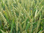 I ask students in my all of my courses what color they see the most when they are outside in the late spring or early summer. Sometimes, they need some prompting; "What is the color of the vegetation you see when you go outside?" Usually, the answer is "green," which is sort of wrong. I'll explain why.
From high school physics, we learned about the Electromagnetic spectrum (EM). The EM spectrum is the range of energies emanating from the Sun and other objects. Our eyes, great as they are, are sensitive to a mere fragment of the entire spectrum of possible energies. The rods and cones in our eyes are stimulated by energies associated with colors ranging from violet to red. A simply mnemonic to remember the colors is ROY G BIV (red, orange, yellow, green, blue, indigo, violet). The arrangement is from longest wavelength to shortest wavelength.
 Our eyes are not sensitive to other energies, like radio waves, cosmic waves, x-rays, microwaves, or even energies just beyond the normal range, infra-red, or ultra-violet. Our natural environment, however, is very adept at reflecting energies beyond the range of our eyes to see.
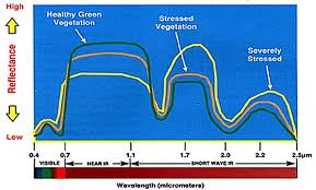
At left, is a graph illustrating the reflectance of energy from the leaves of healthy vegetation, stressed vegetation, and severely stressed vegetation. "Stressed" means the vegetation has been affected by something, lack of water, lack of nutrients, presence of insects, or some form of blight.
Note the range of reflectance energies along the y-axis, and the range of reflectance wavelengths along the x-axis. Along the x-axis, we see the "visible" range, the range our eyes react to, the "near infra-red" range which we cannot see, and the short wave infra-red, which corresponds to thermal (heat) related energy.
 Along the y-axis the reflectance values are indicated. The greater the reflected energy, the higher the reflectance value. Now, note the "visible" range (lower-left). What I mean by saying "green" is sort of a wrong answer is vegetation is obviously reflected far more energy in the near IR and the short wave IR spectrum. I didn't say "green" was "completely wrong," and clearly the reflectance of energy from vegetation is more complex than most people imagine.
To the left is a graphic illustrating what happens when incoming solar radiation strikes the surface of a leaf. The red, green, and blue wavelengths of energy pass through the leaf epidermis. Red and blue are absorbed, while the green wavelength is reflected back by the mesophyll and reaches our eye, and we see the leaf as being "green" as the cones in our eyes are stimulated by color.
When the structure of the leaf changes, the reflectance of the leaf changes. If the leaf lacks water, the epidermis will change color. When the leaf changes "color," we have to ask ourselves, "what is really happening?" What is really happening is the structural change in the leaf is modifying the absorption and reflectance of energy. These changes then manifest as color changes.
Often, when our human eyes detect stress, the plant has already experienced considerable stress. The stress has only just reached the threshold of our eyes to detect. The lack of water, or the presence of too much water, or the blight, acted on the plant well before the ability of our eyes to detect the problem.
One comment before I continue. The "dips" in reflectance values correspond to moisture absorption. Water does not reflect energy well. In fact, one way to find water on remotely-sensed imagery is to look for dark areas in imagery, places where infra-red energy is absorbed. These "dips" are called "water absorption bands."
Knowing something about the EM spectrum AND knowing how different vegetation types reflect energy can lead us toward discovering characteristics about vegetation. We can build sensors to measure reflectance energies in wavelengths we cannot see. These sensors capture and store data, data which can be input into software packages for analysis and interpretation.
Funny, as I write this post, Chris Anderson gave a talk at the San Francisco Bay area MakerFaire a short while ago. The title of his talk, "Farm Drones, Feed the World, Save the Environment, Try Hard To Not Become Self-Aware," gives away the premise of my post.
 The narrative I created earlier was to explain some of the basic theories and technologies. For decades, since the early 1970s, NASA and the USDA have spent hundreds of thousands of man-hours developing technologies for the study of agricultural areas. Satellites LandSAT 1-7 were placed in orbit specifically to capture large amounts of land cover / land cover imagery to support USDA efforts to measure amounts of certain crops. Alongside the efforts to study and measure crops were efforts to analyze and study forest cover. To many, the forest is a crop, silvaculture. In the southern portion of the United States, and the U.S. Northwest, timber is an important industry.
Not only has Landsat been used to help generate data on U.S agricultural products but on global agricultural production. Landsat data measures acreages of crops in other countries. The USDA can estimate crops in the field, acreages, and yields for every country on Earth. Knowing global crop data can help in planning global food production, and also assist in crop pricing.
Satellite imagery is a brilliant data source for large tracts of land. However, if the area of interest is small, such a single farm, the resolution of some satellite imagery is too crude, too course, for proper analysis. For medium- to large-scale farms, drones represent a new technology for farmers and ranchers for farm management.
Drones outfitted with appropriate technology could assist farm managers in the collection of a multitude of different data. For instance, a drone equipped with airborne sensors capable of sensing the near and short infra-red could detect vegetation in various states and types of distress. Further research could determine the type of stress, whether the stress is the result of water, insects, or some form of disease. Data collected by the drone could then be used to direct spraying, or watering.

Drones could assist in the determination of soil chemistry. Just as plants reflect energy which can be used to determine plant health, soils reflect solar radiation which can be used to determine the soil chemistry and moisture. Data could then be used for the direct application of fertilizer.

Drones could even be used in ranching. While I have not heard of such technology in use, yet, the technology exists today to make the following possible. Today, cattle have ear tags. Some ear tags are radio-frequency identification tags (RFID). I can envision a day not too far away where a farm drone is sent aloft to "count" cattle, or to locate lost cattle, or simply map the distribution of cattle on a ranch. If RFID tags are sophisticated enough, cattle from different herds could be distinguished on a map. Even more sophisticated, what if the RFID telemetry was connected to a database table. Perhaps a software app is developed where a farm manager could watch the flight of drone. The head of cattle in view would appear in the viewer with "tags" over their heads tied to the animal's record in the database table. A mouse-over of the tag would fire a database query resulting in a pop-up window illustrating the animal's data, owner, herd number, age, species, etc.
 Flight software for mission planning already exists. ArduPilot (left) is perhaps the best known flight mission planning software for the do-it-yourself drone makers. The drone, equipped with WIFI and GPS, would be capable of being programmed to fly in a specific pattern using a set of waypoints. The drone, equipped with an altitude sensor would also be able to fly at specific altitudes. Therefore, a suitably proficient farm manager, or employee, could use a drone to monitor and manage farm assets.
Visit "DIY Drones" for enthusiastic information on drones.
Drone technology for commercial use in only in its nascent form. The technology has yet to be tested, explored, and analyzed. Drone companies in Europe are paving the way to dominate the global commercial drone market. Drone use in the United States is facing an uphill battle. However, there are many fields and disciplines where drone use is fair, appropriate, educational, informative, and perhaps even necessary. I will explore some of these other fields in future posts.
Shout/Out to readers "Jo," "WalkStx," and BKraxberger for their attention.
PAX
No comments:
Post a Comment