Drones have many applications, are considered by many fields and disciplines to be incredibly useful tools. In my first drone post, I provided an overview of many issues associated with drones. In closing my first post I hinted I would author future posts, offering some current or potential uses. Some of the applications I identify are currently using, with potential for growth; other applications are more future-looking, not in place today, but perhaps in the not-so-distant future.
Drones have been widely used throughout Europe beginning in 2009, perhaps earlier. Prior to the use of drones, manned aircraft were used for evaluating and cataloging archaeological sites. Some of these early imagery collection efforts date back to the 1930s, with the use of fixed-wing aircraft and photography. Some early efforts also used manned balloons and photography.
Early efforts to gather imagery of archaeological sites were costly and time-consuming. A plane had to be hired, a pilot acquired perhaps paid, along with associated fuel costs. Photographs taken might not be adjusted for problems with scale arising from the camera's look-angle, or influences of terrain. Storage of film materials becomes problematic over time, as the film can degrade over time and rendered useless.
 Unmanned aerial systems (UASs) provide several well-documented enhancements over conventional airborne collection, efforts, e.g. piloted planes. UASs can be carried within a suitcase, for example. Models have HD front- and bottom-facing cameras. Some models fly for perhaps 12-15 minutes. Many of the smaller, light-weight models are based on hobby airframes, made of carbon composite materials. The power cells are rechargeable NiCd batteries, powering tiny electric motors. Some models are capable of flying for long durations, 30-60 minutes. These cost more than small universities and college can afford, though.
- The Parrot Drone 2.0

Smaller UASs are able to carry user-installed USB drives. The USB drive stores HD video aboard the UAS, extracted after the drone returns to ground. Many of the UASs available today can be flown from a tablet or smartphone.
One such UAS, the Parrot Drone (Parrot, Inc.) weighs about 4lbs, carries two HD 720p cameras, and can be flown from an Android tablet (Kindle Fire), an Apple iPad, or an Android/iOS-powered smartphone. Live streaming video is sent to the remote control via a secure WIFI connection. The Parrot captures HD video on a user installed USB drive, while pics can be captured during flight straight to the remote control device. The Parrot documentation suggests maximum flight distance from the pilot is about 50m (150ft). Flight time is about 12 minutes with a full charge.
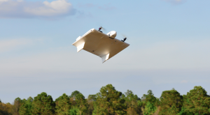
- Aurora Flight Systems SKATE UAS
Some U.S. schools have engaged in inter-disciplinary cooperation. Vanderbilt University, in Nashville, TN., has developed a UAS project based upon the Aurora Flight Systems SKATE platform. In 2012, Vanderbilt garnered some publicity for the use of the SKATE over ruins in Peru.
Archaeologists in the United States are well-behind their European counterparts in the use of aerial systems for mapping, analysis, cataloging, and overall research of North American archaeological sites. Since at least 2009, Italy, France, and the UK have all initiated both academic and national archaeological research projects specifically with UASs in mind.
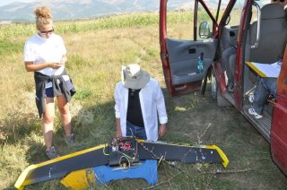
- The Mirkovo Basin research utilized the Quest Systems 200 UAV
In 2012, research sponsored by the Field Museum, Canada, and conducted by Durham University (UK) and the New Bulgarian University (Bulgaria), gathered aerial surveys of important archaeological sites in the Mirkovo Basin (Bulgaria). The unique landscape of the Mirkovo Basin provides over 8,000 years of human settlement history, covering the Neolithic to the modern age of human habitation. Aerial surveys of archaeological sites promises to provide improvements to landscape analysis, cataloging of current sites, with potential use of finding additional unknown sites.
UAS offers fantastic potential for archaeology. Currently, most of the less-expensive UASs are equipped with only HD cameras. More expensive UASs offer thermal imaging capabilities. Thermal imaging technology has the potential to reveal archaeological sites not visible to the human eye. Soil conditions can betray hidden paths, buried foundations, or hint subsurface structures. UASs can be equipped with infrared or multispectral cameras. The human eye, while a wonderful apparatus, is limited in the ability to see wavelengths only between 0.4µm (blue) to 0.7µm (red). Humans cannot see the ultraviolet or the infrared.
When we go outside, we see green trees, grasses, etc., due to the absorption of green electromagnetic (EM) radiation by the 'cone" structures in our eyes. However, vegetation reflects more energy in the infrared portion of the EM. When I tell people vegetation is a poor reflector of green, they look at me like I'm crazy. Chlorophyll response is significantly greater in the infrared than in green, but the human eye cannot see into the infrared. We engineer sensors to reveal the infrared to us, and, in doing so, staying with the domain of archaeology, the sensors can indicate traces of human disturbance. Plants, because they reflect infrared so well, betray changes in soil moisture and chemistry our human eyes are unable to detect. Landscape changes can indicate heretofore undiscovered sites, forts, homes, villages, or cemeteries.
Very expensive drones can be equipped with LiDAR. Light Detection and Ranging (LiDAR) uses lasers to map terrain very accurately. Subtle changes in terrain, when the elevation data are processed and mapped, can be used to analyze historical human landscapes. In some cases, both in Central America and in Southeast Asia, archaeologists have literally walked over archaeological sites without realizing. Only after mapping and surveying, either using ground-based or aerial techniques, did the researchers realize how they had underestimated the size of their study areas.
UASs have the potential to revolutionize archaeology. When coupled with ground survey information, using levels and transits - traditional survey tools, UAVs can provide unparalleled detail for archaeological studies. Geographic information systems, as well as other remote sensing methods, promise to transform the field of archaeology from the stereotypical Indiana Jones stomping around in the jungle, dodging poisonous snakes and toxic darts, to a technology-driven, cutting-edge 21st century digital discipline.
[Archeometry, Department of Geography; Ghent University. The link implies no endorsement. I simply provide as a sample of the peculiar field of archeometry and to illustrate by example the nature of technology use in archaeology.]
No comments:
Post a Comment